Seattle Experiences Travel Issues Due to Looming Snowstorm
The season’s very first snowfall can both be a joyous moment and a dreadful one. For Seattle, their first glimpse at snowfall this winter season was a dreadful one as they brave the streets for their icy commutes.
The entire region was left enveloped in an arctic mass. The freezing mark was something of another story. On Tuesday morning, several areas in Western Washington reported very low freezing marks: Sea-Tac Airport at 20; Boeing Field at 16; Everett at 15; Tacoma at 12; and Arlington at just 8 degrees!
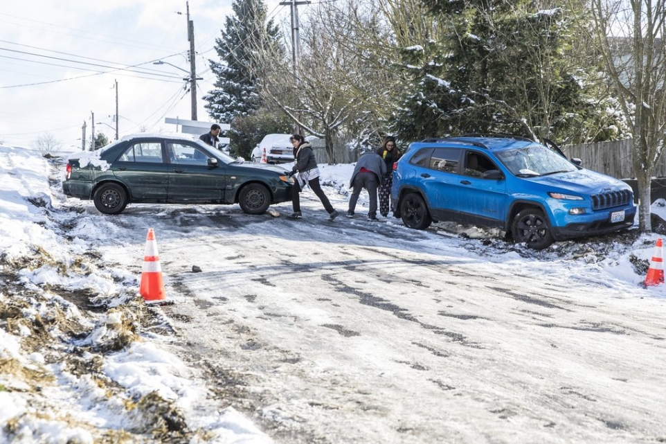
There were also several accidents reported on that morning due to the slippery and icy roads. Despite the announcements made by the Washington State Police Department, people still pushed through with their travels. The drivers that were interviewed claimed that they wished they had made a different decision that morning.
Schools Closed Due to Snow-Covered Routes
In addition, more than 200 schools were closed. Some of them had delayed openings but a majority were closed so as to avoid any further accidents that may arise from driving on the cold icy streets. Schools near the Puget Sound area were closed due to snow-covered routes.
Other schools that were closed due to the snowfall of the season included public schools in Bellingham, Federal Way, Kent, Renton, Shoreline, Highline, Lake Washington, Bellevue, and Seattle.
Expect Heavier Snowfall This Coming Friday or Saturday
The National Weather Service in Seattle also announced that there is a possibility of a heavier snowfall this coming Friday or Saturday. Steve Reedy, a meteorologist, claimed that this is not the time to “breathe easy” as the worst is yet to come. Neighboring towns may experience something as dreadful as that of the areas at Puget Sound.
Meteorologist Steve Reedy Explains Seattle Snowfall
In addition, Steve Reedy explained that the cold system that is about to drop on Friday or Saturday is the same cold system Seattle may be experiencing now. This system swoops down from Central British Columbia in which the Arctic air has traveled all the way from Fraser River Valley. This will then be channeled down into Washington.
News on Garbage Collection in Seattle: Monday Customers Get No Additional Fees for Double the Amount
Furthermore, this news can also mean no residential garbage collection in Seattle – or the rest of the region for that matter. Tuesday customers leave out the garbage collection for Wednesday pickup. However, for Monday customers, they would need to wait until the next Monday for pickup, double the amount for no additional fees. Don’t fret! The Waste Management customers can always check online for any news on when the garbage collection service will resume.
Keeping the Roads Safe
On other news, a fleet of trucks who had worked night shifts to ensure a safe road for travelers will continue to work into the morning. They will proceed to keep King County’s roads as safe as possible for the people. The process included putting a mixture of sand and salt into each automobile, then adding calcium chloride.
A Message From the Washing State Patrol
Do keep in mind that despite the efforts to keep all roads free from accidents, state troopers still advise everyone to stay in their homes and off the roads. Moreover, if there is a need to drive down the road for emergency purposes, slow down and increase your following distance. Of course, these are all precautionary measures so as to avoid any unnecessary accidents that may cause lives. As soon as snowfall hits Seattle last Sunday, there has been a report of 577 calls received by the Washing State Patrol regarding spinouts, disabled cars, and car crashes.
What Seattle Should Expect This Weekend
On the brighter side of things, there have been reports that the sun may rise and allow the ice to melt in the afternoon. However, these might just freeze up again come Tuesday night. Reporters claimed that Seattle and its neighboring areas are actually in between storms as they experience days that are below 20 degrees and days that are much warmer than the day before.
Nonetheless, it is advisable to remain calm and alert. The National Weather Service states that this is “potentially significant.” The incoming storm is just a repeated scenario of what Seattle just went through. The only difference is that the incoming snow storm is more potent than the previous one. If the winds are also significant, it is possible that it could add several inches of snow to the Hood Canal and Olympic Peninsula area.
Always be prepared at times like these. Luckily, there are a lot of platforms that provide updates regarding a potentially snowy weekend.


Leave A Comment