Well, it’s official – as of September 21, 2019 Seattle’s iconic, two-tiered freeway is no more.
Public reaction has varied. But then again, the Viaduct was nothing if not divisive, both literally and figuratively, from its very inception. Whether you loved it for the views, hated it for the delays, trembled at the danger or were thrilled by it, the Viaduct formed an integral part of Seattle’s landscape for over 60 years, so it may be worth remembering how we got here.
The Road Thus Travelled
When construction on the Alaskan Way Viaduct first began in the 1940s, the barrier it created between the Waterfront and the rest of downtown was intentional: shipping was the name of the game, and the Viaduct was built in part to protect maritime commerce from increasing vehicular and foot traffic over the previous decade.
It may have succeeded in that mission, but criticism rose right along with the steel and concrete, calling the structure “cold” and “inhospitable” – not to mention noisy. Proposals to replace or change it came as early as 1968. Then, an elevated highway in California similar to the Viaduct collapsed in a 1989 earthquake, and a whole new set of concerns emerged.
Engineer reports requested by the Washington State Department of Transportation exposed the Viaduct’s seismic vulnerability, and the final tipping point came in 2001 when the Nisqually Earthquake damaged the Viaduct itself. It was time to make a decision.
Light at the End of the Tunnel
In 2009, after several years (and over 90 options considered), the portion running through SoDo was demolished and replaced with the six-lane Alaskan Freeway in 2011. Two years later, the boring machine “Bertha” began excavating the new SR 99 Tunnel, a project fraught with delays. Again, while many were frustrated, others surely smiled as the Viaduct stood defiant through the next five years.
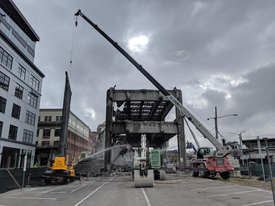
Finally, Bertha completed her excavation in 2017 and tunnel construction could begin. When it opened on February 4 of this year and the Viaduct had carried its last commuters to and fro along the coast, the demo crews moved in.
Led by Kelly Arnold of Ferma Corp., jackhammers, cranes, and concrete munchers punched, cheweed, and sawed their way through the concrete roadways between the girders and hydraulic crunching jaws dismantled the columns and steel beams. As a time-lapse video released by WSDoT shows, crews sometimes worked with precision care just inches from buildings and with people, trains, or traffic still flowing dozens of feet below.
The Way Forward
The final span was removed in September at Marion Street across from Colman Dock. Rubble cleanup is up next; then the city kicks into high gear on its Waterfront Renewal plan, estimated to take around 3-4 years and cost between $700-750 million (although the city’s taxpayers only have to cover around $250 million of that).
Some of the renewal projects underway include the redesigned Alaskan Way surface street moving east to allow for more pedestrian access, and a new Ferry Walkway to replace the old.
Other elements are in various states of construction:
-A new elevated pathway connecting Pike Place Market to the Waterfront
-New and restored parks and public spaces at Pier 58, Overlook Walk, and Pioneer Square
-A new concert venue at Pier 62, opening in 2020
-An expanded Seattle Aquarium and Oceans Pavilion
These and more can be followed on the Seattle Waterfront website.


Leave A Comment